5 River Bank Erosion in India
The rivers in India (Figure 4*) can be broadly divided into four regions related to erosion problems.
 http://nroer.in/gstudio/resources/imagecollection/colln/35270/
5.1 North West Region
The main rivers in this region are Sutlej, Beas, Ravi, Chenab and Jhelum, the tributaries of Indus, all flowing from the Himalayas. Compared to River Ganges and Brahmaputra River region, the flood and erosion problems are relatively low in this region. The major problem is that of inadequate surface drainage, which causes inundation and water logging over vast areas.
5.2 Central India and Deccan Region
The important rivers in this region are Narmada, Tapi, Mahanadi, Godavari, Krishna and Cauvery. These rivers have mostly well defined stable courses. They have adequate capacity within the natural banks to carry the flood discharge, except in the delta area. The lower reaches of the important rivers on the East Coast have been embanked, thus largely eliminating the flood and erosion problems.
5.3 Brahmaputra Region
This region consists of the rivers Brahmaputra and Barak and their tributaries covering seven states Assam, Arunachal Pradesh, Meghalaya, Mizoram, Northern parts of West Bengal, Manipur, Tripura and Nagaland. Out of its total length of 2880 km the Brahmaputra River flows 1625 km in Tibet as Tsangpo before entering India through Arunachal Pradesh. The river crosses Assam below Dhubri and enters Bangladesh where the river is known as Jamuna and where it flows for 337 km. Its tributaries in India are Dibang, Lohit, Dhansiri, Kameng, Raidak, Jaldhaka and Teesta rivers.In India, state-wise the drainage area of the Brahmaputra River and its tributaries is shown in Table 4. The Assam and West Bengal portion of the Brahmaputra River basin are mostly plain areas, whereas Arunachal Pradesh, Meghalaya and Nagaland parts are mainly covered by mountain ranges, hills and narrow valleys. In India, among all Eastern and North-eastern states, Assam faces the most severe brunt of Brahmaputra bank erosion.
| States in India | Drainage area (km2) | Percentage of state area in |
| Brahmaputra River basin | ||
| Arunachal Pradesh | 83 740 | 100.00 |
| Assam | 71 216 | 90.79 |
| West Bengal | 12 585 | 14.18 |
| Meghalaya | 11 780 | 52.52 |
| Nagaland | 10 895 | 65.71 |
| Sikkim | 7100 | 100.00 |
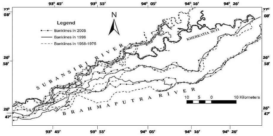
According to the records of the last century, the Assam valley portion of Brahmaputra River occupied around 4000 km2 in the 1920s, which is now around 6000 km2 (Phukan et al., 2012). The satellite image estimation shows that the total land loss per year due to erosion of Brahmaputra ranges from 72.5 to 80 km2/year during 1997 to 2007 – 2008 (Figure 5*). Bank erosion has wiped out more than 2500 villages and 18 towns including sites of cultural heritage and tea gardens, affecting the lives of nearly 500 000 people.
5.4 Ganga (Ganges) Region
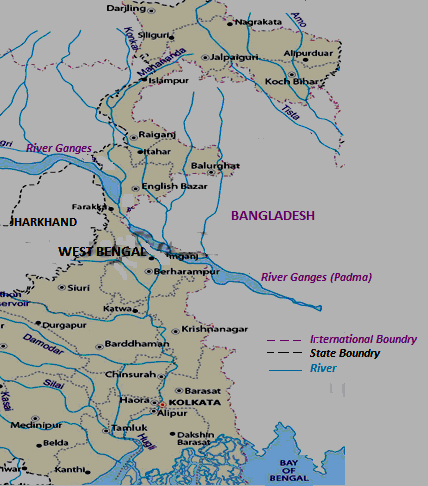
The River Ganges and its numerous tributaries cover the states of Uttaranchal, Uttar Pradesh, Jharkhand, Bihar, South and Central parts of West Bengal, parts of Haryana, Himachal Pradesh, Rajasthan, Madhya Pradesh and Delhi (Figure 4*). Even though the Ganges is a long river carrying huge discharges of up to 70 000 m3/s, the erosion problems are confined to relatively few places. The flood and erosion problems are serious in the lower Ganges region, particularly in West Bengal.The River Ganges enters West Bengal near Rajmahal in Jharkhand state and then it flows in a South-easterly direction within West Bengal (Figure 6*). After flowing through Malda district it divides into two branches near North of Dhulian in the Murshidabad district. One branch enters Bangladesh as the Padma, while the other flows through West Bengal as the Bhagirathi River and Hooghly River in Southern direction. The Bhagirathi is the main river in West Bengal, which flows past the Murshidabad, Nadia, Burdwan and Hooghly districts and contributes to a dominant irreparable loss of land each year.
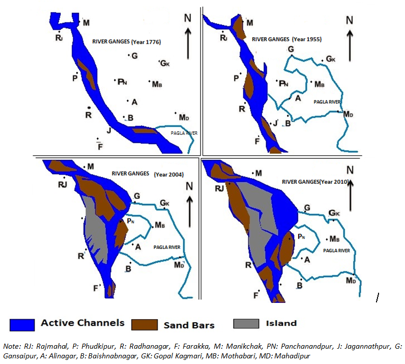
Bank erosion is a common phenomenon in any uncontrolled channel of the deltaic tract. But the case of the River Ganges in West Bengal is quite different. The upstream is so clogged with sediment that the river is compelled to alter its course. The course of the Ganges along the Northern river-front of West Bengal has been fast changing due to unabated bank erosion, especially over the last few decades. The Ganges in Malda district in the upstream of Farakka Barrage has been undergoing extensive erosion along the left bank even though it has been strongly protected (Figure 7*).
However, the erosion problem is not only restricted in the upstream section, it is also widespread throughout its course in West Bengal. One of the major reasons is Farakka Barrage. Farakka Barrage is a dam on the Bhagirathi River located in West Bengal state in India. It is located about 10 km from the border to Bangladesh. The dam was built to divert the Ganges River water into the Hooghly River during the dry season in order to flush out the accumulating silt, which was a problem at the Kolkata Port on the Hooghly River. Now it is well accepted that the intensity of the Ganges-bank erosion in West Bengal has increased after the construction of Farakka Barrage (Rudra, 2010). Official reports show that on an average 8 km2 of land are engulfed annually by the river in West Bengal.
 |
 |
 |
Living Rev. Landscape Res., 8 (2014), 3, doi:10.12942/lrlr-2014-3, URL (accessed <date>): http://lrlr.landscapeonline.de/lrlr-2014-3.
 This work is licensed under a Creative Commons License.
© The author(s), except where otherwise noted.
This work is licensed under a Creative Commons License.
© The author(s), except where otherwise noted.