List of Figures
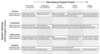 |
Figure 1:
Anthropogenic impacts, including altered land cover and hydromodification, drive physical, hydrological, chemical, and biological riverine response at the basin scale; these changes trickle down through the watershed scale, the stream scale and finally to reach-scale impacts on habitat and biota. 1 Hydromodification includes anything that modifies/disrupts the flow of water or aquatic animals (i.e., dams, culverts, weirs, armored banks, levees, ditches). |
 |
Figure 2:
Aerial photo of a tributary of the Sarufutsu River, Japan, by DMC (digital mapping camera). Field-validated instream features such as woody debris (red lines), log jam (thick orange line), and deep pools (green circles) are superimposed. The field mapping of these features closely matches the photo imagery. |
 |
Figure I:
The Upper Mainstem Willamette River, Oregon, USA. Photo by Steve Cline, USEPA-Corvallis. Despite being channelized in the early 20th century and having multiple hydropower dams in its major tributaries, the upper mainstem of this floodplain river retains channel complexity in the form of side channels, islands, and alcoves. |
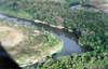 |
Figure II:
Rio das Velhas, Minas Gerais, Brazil. Photo taken by Carlos Alves, Manuelzao Project. Lacking mainstem or major tributary dams, the das Velhas floods during the rainy season and supports multiple, permanent, off-channel lakes (lagoas) providing reproductive and rearing habitat for aquatic vertebrates. |
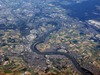 |
Figure III:
Upper Danube River, Germany. Photo taken by Ashley Steel. This large floodplain river has lost much of its floodplain connectivity as a result of channelization and system-wide dams and locks. |
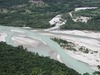 |
Figure IV:
Tagliamento River, Italy. Photo taken by Susanne Muhar. The Tagliamento is one of the largest undammed rivers in western Europe and its braided and anastamosed channels are indicative of high bedload from the Alps. |
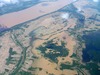 |
Figure V:
Mekong River and its tributary in Cambodia. Photo taken by Seiichi Nohara during the rainy season. The tributary of this floodplain river is visible only because the riparian forest canopy is barely higher than the water level. |
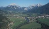 |
Figure VI:
The River Enns, Styria, Austria. Photo from Gesaeuse National Park. Hydropower dams, canals, and channelization limit connectivity of the Enns with its floodplain. |
 |
Figure VII:
Intermittent tributaries of the Calapooia River, Oregon, USA. Photo by Randy Colvin, Department of Fisheries and Wildlife, Oregon State University. Nearly all of the visible channels (agricultural ditches) are only wet during the rainy season, yet they provide overwintering refuge habitat for spawning and rearing native fish, including salmonids. |
E. Ashley Steel et al., "Are We Meeting the Challenges
of Landscape-Scale Riverine Research?
A Review",
Living Rev. Landscape Res., 4 (2010), 1, doi:10.12942/lrlr-2010-1, URL (accessed <date>): http://lrlr.landscapeonline.de/lrlr-2010-1. This work is licensed under a Creative Commons License.
© The author(s), except where otherwise noted.
This work is licensed under a Creative Commons License.
© The author(s), except where otherwise noted.
of Landscape-Scale Riverine Research?
A Review",
Living Rev. Landscape Res., 4 (2010), 1, doi:10.12942/lrlr-2010-1, URL (accessed <date>): http://lrlr.landscapeonline.de/lrlr-2010-1.
This work is licensed under a Creative Commons License.
© The author(s), except where otherwise noted.